
Enter a zip code to see how intense the earthquake was for particular locations.
The search engine returns a figure to indicate quake intensity.
(One problem: the intensity numbers are given in Arabic numerals. Yet the cited magnitude scale on the page is not the Richter Scale, but the Modified Mercalli Intensity Scale, which is given in Roman numerals. The USGS site says that it is not giving quake intensity in Richter measurements, yet it is not saying which scale the indicated numbers match to.)
QUAKE PATTERN RELEVANCE FOR DISCUSSIONS OF NUCLEAR PLANT VULNERABILITY
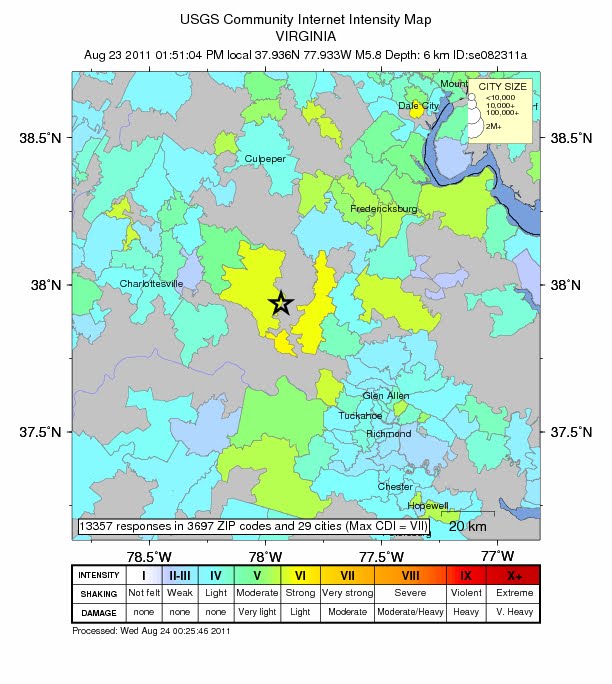
One might argue that the quake could not harm distant locations if it did not affect closer locations. Yet if one looks at the map of the intensity readings for the quake one sees that the clusters of earthquake strength are not clustered in a continuous pattern next to the Mineral, Virginia epicenter. Some places have light or negligible vibrations from the earthquake tremors. Yet, a distance further away did record strong quake readings.
See for your self from the map immediately below. (The trajectory of the quake from Mineral, Virginia, northeast-ward toward lower New England appears to follow along the Ramapo Fault.
Other references to the Ramapo Fault:
http://www.wnyc.org/blogs/wnyc-news-blog/2011/mar/14/look-tri-states-active-fault-line/
http://slatest.slate.com/posts/2011/08/23/east_coast_fault_lines_virginia_earthquake_highlights_significan.html

Here is a closer view of the map of the Mineral, Louisa County, Virginia area of the earthquake.


No comments:
Post a Comment