Showing posts with label 2011 Virginia earthquake. Show all posts

Tuesday, August 23, 2011

Search for 8/23 earthquake intensity for your ZIP Code; ramifications for nuclear plant considerations

PBS News Hour "The Rundown Blog" has a link to a U.S. Geological Survey search engine for the August 23, 2011 earthquake (now reported as 5.8) intensity at various East Coast locations.

Enter a zip code to see how intense the earthquake was for particular locations.
The search engine returns a figure to indicate quake intensity.

(One problem: the intensity numbers are given in Arabic numerals. Yet the cited magnitude scale on the page is not the Richter Scale, but the Modified Mercalli Intensity Scale, which is given in Roman numerals. The USGS site says that it is not giving quake intensity in Richter measurements, yet it is not saying which scale the indicated numbers match to.)

QUAKE PATTERN RELEVANCE FOR DISCUSSIONS OF NUCLEAR PLANT VULNERABILITY
One might argue that the quake could not harm distant locations if it did not affect closer locations. Yet if one looks at the map of the intensity readings for the quake one sees that the clusters of earthquake strength are not clustered in a continuous pattern next to the Mineral, Virginia epicenter. Some places have light or negligible vibrations from the earthquake tremors. Yet, a distance further away did record strong quake readings.
See for your self from the map immediately below. (The trajectory of the quake from Mineral, Virginia, northeast-ward toward lower New England appears to follow along the Ramapo Fault.
Other references to the Ramapo Fault:
http://www.wnyc.org/blogs/wnyc-news-blog/2011/mar/14/look-tri-states-active-fault-line/
http://slatest.slate.com/posts/2011/08/23/east_coast_fault_lines_virginia_earthquake_highlights_significan.html


Here is a closer view of the map of the Mineral, Louisa County, Virginia area of the earthquake.
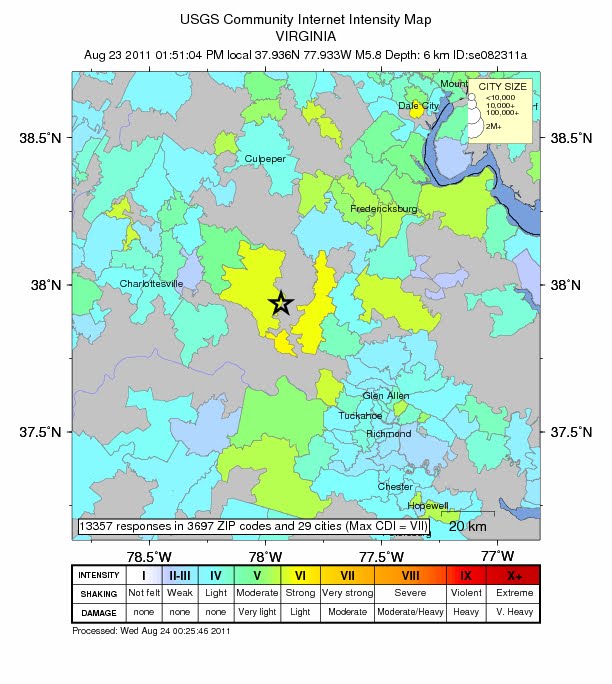
Did we almost lose Charlottesville?

Has any of the promoters or defenders of nuclear power considered how the nuclear plants in the United states are on or close to seismic (earthquake) zones or fault lines?

With the 2011 Virginia earthquake today one might argue that we came close to losing Charlottesville.

Consider the nuclear power plants and the earthquake activity in the area, just in the years since these plants were operational in the 1970s. As I blogged earlier today in part of a post:
NUCLEAR POWER PLANTS IN THE REGION, ALONG WITH SEISMIC ACTIVITY
Wonder how people in the Maryland/DC/Virginia area feel about the relatively old nuclear power plants in eastern Virginia and southern Maryland: Calvert Cliffs (operative since 1975) in Maryland on the Chesapeake Bay, North Anna Nuclear Generating Station (just 11 miles from the earthquake epicenter, and operative since 1978), near Charlottesville, Virginia and Surry Nuclear Power Plant (operative since 1972) in the Norfolk/Virginia Beach, Virginia vicinity.

The wikipedia article for the Virginia Seismic Zone reports that there have been several quakes in the past decade in the area, albeit with mild readings, around 3.6. Just over the Potomac River lies the site of the 2010 Germantown, Maryland earthquake (the Potomac-Shenandoah Earthquake, as labeled by Wikipedia), 3.6 on the Richter Scale. The North Anna plant is sited precisely in the Virginia Seismic Zone.

Another site to note: Andrew Schenkel, "Nuclear power and earthquake zones overlap in the U.S.: Earthquake in Japan raises concerns about what could happen in the U.S." in Mother Nature News, March 11, 2011.

Moderate earthquakes hit Virginia AND Colorado

Monday night an earthquake of 5.8 Richter scale strength hit southern Colorado in the area of the border with New Mexico, Monday, August 22, 2011, evening. It was the largest quake to hit Colorado in more than a century.

Receiving much more media attention was the earthquake to hit Mineral, Virginia today, August 23, at about 1:00 PM in the center of the state. Mineral, the epicenter town, is midway between Charlottesville and Fredericksburg, fifty miles from Richmond. In media reports it has been identified as the Washington, D.C. earthquake. It was reported as being a 5.9 scale earthquake. This would be the strongest earthquake in the Mid-Atlantic region in decades. It exceeds a 2003 central Virginia earthquake of 4.5, and the 1998 Pymatuning earthquake in northeast Pennsylvania, with a 5.2 reading.

This second earthquake has been reported felt as far as Toronto, Ontario; Detroit, Michigan; North Carolina and Massachusetts. Source: "5.9 earthquake in Virginia shakes East Coast, rattles Michigan office buildings," "Detroit Free Press."

NUCLEAR POWER PLANTS IN THE REGION, ALONG WITH SEISMIC ACTIVITY
Wonder how people in the Maryland/DC/Virginia area feel about the relatively old nuclear power plants in eastern Virginia and southern Maryland: Calvert Cliffs (operative since 1975) in Maryland on the Chesapeake Bay, North Anna Nuclear Generating Station (operative since 1978), near Charlottesville, Virginia and Surry Nuclear Power Plant (operative since 1972) in the Norfolk/Virginia Beach, Virginia vicinity.

The wikipedia article for the Virginia Seismic Zone reports that there have been several quakes in the past decade in the area, albeit with mild readings, around 3.6. Just over the Potomac River lies the site of the 2010 Germantown, Maryland earthquake (the Potomac-Shenandoah Earthquake, as labeled by Wikipedia), 3.6 on the Richter Scale. The North Anna plant is sited precisely in the Virginia Seismic Zone.